
The Stafford–Shrewsbury line formerly ran between Shrewsbury and Stafford, from 1849 to 1966.
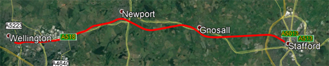
Those paying attention will spot that the little thing above only shows Wellington to Stafford… and for good reason – the line between Shrewsbury and Wellington is still in use, and here I’m only interested in the closed parts.
Opened in 1849, closed to passengers in 1964, and goods in 1966, the line was cut back to Donnington by the end of 1969.
A now deceased associate once told me that the Stafford to Donnington section was lifted over the course of a month, and that the sleepers had to be destroyed and the rail taken away as fast as possible, in case somebody changed their mind.
The last stretch of Wellington to Donnington track was lifted in 1991.
Shortly afterwards, the 21st Century arrived.
It took a while to get going (not the Century!), but between 2008 and 2009, a single track line was rebuilt between the junction at Wellington and the new Telford International Railfreight Park, built at Donnington (like you really didn’t see that coming!)
Also in 2009, the Association of Train Operating Companies proposed the reopening of the Stafford=Shrewsbury line as part of their £500m plan to try to undo some of the Beeching Axe choppings.
In March 2011, a group called the Shropshire, Telford and the Marches Strategic Rail Group lobbied to re-open the line, and rebuild some of the intermediate stations.
In January 2019, Campaign for Better Transport released a report identifying the line which was listed as Priority 2 for reopening. Priority 2 is for those lines which require further development or a change in circumstances (such as housing developments).
In January 2020 the UK Government announced a £500m fund to support the reopening of disused stations and lines closed under the Beeching cuts. The Shropshire, Telford and the Marches Strategic Rail Group and Wrekin MP Mark Pritchard called for the reopening of the Stafford-Shrewsbury Line to reconnect Donnington and Newport.
All of this is, of course, just pointless. Nobody ever considered the possibility of the line reopening, so it was never protected.
Because there is no joined up thinking between agencies in this country, you have the absolute farce of one lot saying “yeah, that would be a goof line to re-open”, while others are frantically building houses and roads in the way, seemingly deliberately.
Starting over on the eastern end of the route, the A518 New Trench Road from Garrison Roundabout to near Honnington lies smack on the route. The was built in the ’90s, so you can’t be too hard on them.
When you get into the southern parts of Newport (Church Aston), you have a strange arrangement of bridges over nothing, and the line of the route going through gardens, such as those on Wallshead Way and Station Court. And there are a few Industrial units in the way. Next comes a huge hurdle
From the A41 crossing all the way to just before Stafford, the route is now a cycle trail. Any attepmpt to claw it back would be met by an army of lycra-clad shitehawks banging on about losing their rights. Cyclists are worse than Ramblers, and Ramblers are pretty fucking annoying.
And then at the end of the psychopath-path we hit another 2010’s build housing estate, built *AFTER* the first re-opening proposal:

And, next, oh so very close to the main line connection at Stafford, we have the final obstacle… There used to be a siding that ran up the back of this factory:

But that factory isn’t there anymore, and if you can’t see what is coming up between the roads at the north edge and the rundabout in the southeast, then you are thicker than all the residents of this housing estate put together:

For these people are now wanting compensation for the increased traffic on their access road (which was in the planning stages before the first house was sold). They’ll utterly lose it when they find about the plans for the other 4,500 houses that are going to get builton the back of that estate!
Anyway, here is the new road layout (built 2021):

But that’s ok, cos surely the line will be crossed by an overbridge?
Well, sadly not:

Well. that has fucked that, hasn’t it?
Yes, for some reason connected with either cost-cutting, back-handers or just plain half-arsery, the new road cuts across the new line, not at “ground level”, but at such a height that either a level crossing or a “dive-under” would present gradients too steep to be usable. Brilliant thinking, and a proper kibosh for the line.
So I suppose that’s it for this rant? Well, actually. no.This part of Stafford contains one of my favourite little historical oddies. This bridge:

The bridge was originally built to carry the Doxey road over the Stafford to Uttoxeter Railway, but today it stands alone, redundant and useless.

I bet it “accidentally” gets knocked down while the road construction is going on.
We absolutely should see a line to Newport and Shrewsbury (there are, for instance, kids sitting on the bus over an hour each way to get to Stafford College for courses not available in Newport, which would be about 15minutes on a train).
There isn’t however, so much need for the hate on cyclists. The biggest issue – as you say – is the failure to protect the corridors. Indeed, cycle paths are sometimes quite handy for this, as developers will build around them. Routes are often still publicly owned and won’t be in the parcel a developer buys, so the site will naturally follow old rail boundaries. It is very unfortunate that overbuild has happened in Doxey.
Nonetheless, active travel routes are good and to be encouraged.
In the second, we should not be “reopening” any lines at all. We should be building *new* lines, which meet modern needs. In many cases, these lines might borrow old trackbed or (logically) reinstate old routes – but perhaps straighter and faster. There is some idea that reopening old lines is “cheap”, and indeed you sometimes have an easier time of planning – but to install a modern line you’re still basically building from scratch, including digging down and building up sub-grade and sorting drainage to modern standards. Just because there’s a flattish cyclepath doesn’t mean we can simply dump down some ballast and lay track!
In the case of the Stafford-Shrewsbury route, it was double-track and decently straight (unlike the Cambrian line winding it’s way round to Barmouth or Aberystwyth), so the old alignment is probably quite useful. There’s a question though about whether the bridges are universally high enough to support electrification (let’s face it, we shouldn’t be building unelectrified lines in 2024, especially for local services with frequent stopping, where you want nippy acceleration). The old Doxey bridge on the Uttoxeter line is a classic case of this dubious clearance. A new line would likely call for a new bridge (although the Isabel Trail is far too heavily used to reinstate as rail these days, plus the MoD wouldn’t let you punch into their land north of Beaconside anyway – a new Uttoxeter line would need a new route). We also need to consider whether there are farm crossings (there are) – because nobody is building level crossings in 2024. So that would mean more bridges/underpasses/etc which affect the track grade and civils. It’s a new line project, even if it’s roughly-in-the-same-place-as-a-former-line-if-you-squint-a-bit.
By the time you’ve done all that, there would be little difficulty in accommodating an active travel route alongside the tracks.
If this project ever got off the ground, it’s basically a full rebuild that would use old alignment *where convenient*. We shouldn’t bemoan that use by walkers and cyclists in the intermission has kept the route open, and indeed stopped England Highways filling some of the bridges with concrete!
Wow. An educated an useful comment! I’m astounded. As for the MOD question, just wait a few years for the land to be sold off. The parcel to that side of the line is the “residential” part of the site and thus not riddled with the problematic storage tunnels that run under the place.
Thankyou, that’s very kind!
The Uttoxeter line is definitely harder – it was only single track to start with, and with all the residential and commercial development butting up to the Trail, it would involve a huge amount of CPO to wipe out people’s back gardens and clear the route back on what is already a narrow corridor (and the Ambulance station/call centre is a not-gonna-move bit of regional infrastructure). It’s also a hugely important corridor for kids going to school, dog walking, ParkRun, and of course runs through nature reserves at Doxey and Astonfields.
It’s the “easy” end of the MOD, but they’ve spent a lot of money up there in the past 10 years which they’d be reticent to write off any time soon. And Stafford is now well reprieved (after being on the chopping block) when they realised they needed somewhere to bring back British Forces Germany. It’s unlikely to go anywhere soon.
Outside Stafford it also runs through a golf course (far worse than cyclists), equine unit and other housing around villages. It’s also wiggly as balls, so probably an all-new alignment.
The other consideration is that the thousands of new houses in Uttoxeter hug the A50, and the railway line is in the bottom of the valley. It would be desirable to have a Uttoxeter-West station for those estates, but it would effectively be a weird out-of-town parkway. The Stoke-Derby line actually needs realigning to come north of Bramshall, and you could have a freight spur over the JCB (now they’re building a big logistics site at Castle Donington, which has a rail link), keep trucks off the A50.
I wonder if you could cut-and-cover up the Isabel Trail. Portal in around the Eccleshall Road Cemetary, a sunken station on the Common and underneath the Beaconside/Sandin Road Bridge, then *underneath* the MoD. There is a lot of water around Marston Brook – there’s a reason the trail is elevated, and drainage is quite important to not flooding the town!
I think you’re either going north around the new Beaconside developments, or committing to boring (deep enough to be below drainage infrastructure) – at which point you can go wherever you like.
Of course it could also be kept single-track in Stafford (3km of 20km), which is a short enough span that you wouldn’t inhibit a decent service frequency or become too much of a bottleneck if the rest is dualled.
Just imagine for a moment we are doing that “out of the box” thinking that is so vaunted by the whatevers.
As the trackbed from the station to the MOD site is pretty much available (apart from the Doxey Road crossing).
This passes three major industrial estates and a lot of housing.
Tramway?
(Do not look at Trampower’s abortive attempts to do the same thing in Preston on a similarly abandoned line – they’ve arsed it up from Day One).